Information about the city Ancash
Ancash is a region of northern Peru. It is bordered by La Libertad Region on the north, Huánuco and Pasco regions on the east, the Lima Region on the south, and the Pacific Ocean on the west. Its capital is the city of Huaraz, and its largest city and port is Chimbote. The name of the region originates from the Quechua word anqash (light, of little weight), from anqas (blue) or from anka (eagle). Ancash is a land of contrasts: it features two great longitudinal valleys, which combine the mountain characteristics of the Callejón de Huaylas (Alley of Huaylas) with the sylvan ones of the Alto Marañón. Miles of sandy beaches and the blue waters of the Pacific. The territory of the coast, high plateaux and Andean punas of the Ancash Region are flat, while the rest of the territory, in the Andes, is very rough. In the west, slopes with strong declivity form narrow canyons with abrupt and deserted sides. The rough territory of the region is crossed by two mountain ranges: on the western side, the Cordillera Negra (Spanish for "black mountain range"), which has peaks without glaciers, and on the eastern side, the Cordillera Blanca ("white mountain range"), which has many peaks covered with snow and ice, such as the Huascarán and the Alpamayo. Between these two mountain ranges, the Santa River flows through the so-called Callejón de Huaylas. This valley narrows to form the Cañón del Pato ("duck canyon"). Also along the Pacific slopes, the Santa River has shaped a wide valley in the punas which narrows into the Cordillera Negra, where the Cañón del Pato canyon was formed. The snow-covered peak of Huascarán, highest peak of Peru and second of the Americas, reaches a height of 6,768 m (22,205 ft, 4.2 miles) and contrasts with the 6,263 m (20,548 ft) deep trough of Chimbote found in the ocean west of Ancash. Remnants of glaciers created many lakes such as Llanganuco Lakes and Lake Parón. Following the Pan-American Highway north from Lima, the territory of the region of Ancash begins just beyond the Fortress of Paramonga, between wide fields of sugarcane, and across the Fortaleza River, 206 kilometres (128 mi) from Lima. Along the coast of Ancash, from the Fortaleza River to the Santa River, the Pacific exerts great influence. The Peruvian current and the El Niño current exert considerable and sometimes tragic effect on local lives and regional economies. Normally, the Peruvian current, also known as the Humboldt Current, brings cold water and large numbers of fish. With the development of the shoals of anchoveta, the Ancash ports and creeks became commercial fishing centers. During the 1950s, the bay of Chimbote was the top fishing port of the world. However, when warmer waters from the north, such as the current of El Niño, bring catastrophic rains to the coast and sea, the shoals of anchoveta disappear, leaving the fishing fleets plants paralyzed, and flooding rivers cause serious damage to the lands and cities. The cycles of these two sea currents that affect Peru are hard to predict. Further north along the Pan-American highway, numerous islands and islets dot the sea near the coast. Most are home only to guano seabirds. From south to north, the most important islands include Tortuga Island (Turtle Island), La Viuda Island (The Widow Island), Isla Blanca (White Island) and Santa Island (Holy Island). The coastal region of Peru includes many peninsulas, creeks, warm bays and sand beaches, full of color. Because of the lack of roads and difficult terrain, many of these are inaccessible by land. The most important beaches include Grande Beach, La Gramita Beach and Las Salinas Beach. Much of this coast is a monotonous stretch of huge sand deserts, a common denominator in all Peruvian coastal regions because of the influence of the Humboldt Current. Along the rivers, there are green valleys, cultivated mainly with sugarcane, rice and cotton. From south to north, the main rivers of the Ancash coast are the following: Huarmey, Culebras, Casma, Sechín, Nepeña, Lacramarca and Santa. Of these rivers, the only one with water year-round is the Santa River. Its sources are the glaciers and lakes of the Cordillera Blanca. The other rivers, as with most rivers of the Peruvian coast, are intermittent, depending on the highland rains or the advance of El Niño.
Information about the city Arequipa
Tickets to Arequipa on recorrido.pe
|
Route |
Bus company |
Price |
Departure times |
|
Lima a Arequipa |
Movil Bus |
S/ 90 |
15:00 15:30 16:00 16:30 |
|
Lima a Arequipa |
Cromotex |
S/ 100 |
13:00 14:30 17:00 18:00 19:00 20:00 21:00 |
| Lima a Arequipa | TEPSA | S/ 110 | 14:00 15:00 15:35 19:15 20:30 21:00 |
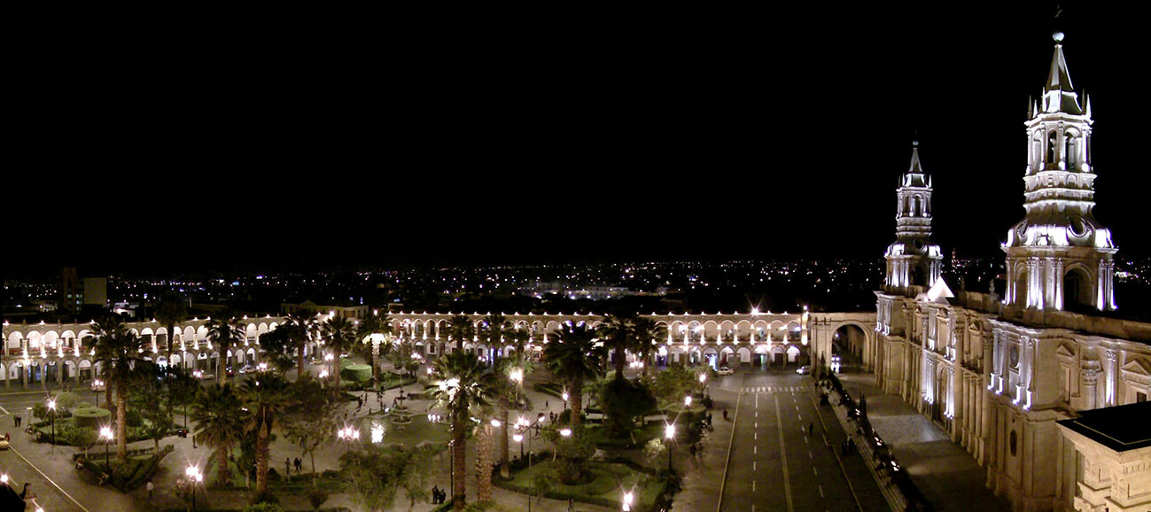
Arequipa is the capital and largest city of the Arequipa Region and the seat of the Constitutional Court of Peru. It is Peru's second most populous city with 861,145 inhabitants, as well as its second most populous metropolitan area as of 2016, according to the National Institute of Statistics and Informatics (INEI).
Arequipa is the second most industrialized and commercialized city in Peru. Its industrial activity includes manufactured goods and camelid wool products for export. The city has close trade ties with Chile, Bolivia and Brazil.
The city was founded on 15 August 1540, by Garcí Manuel de Carbajal as "Villa Hermosa de Nuestra Señora de la Asunción". During the Colonial period, Arequipa became highly important for its economic prosperity[4] and for its loyalty to the Spanish Crown.
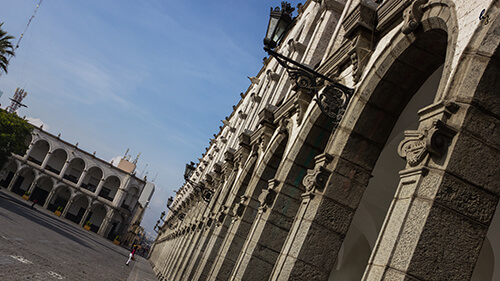
After Peru gained its independence from Spain in 1821, Arequipa acquired greater political significance, and was declared the capital city of Peru from 1835 to 1883. The historic center of Arequipa spans an area of 332 hectares and is a UNESCO World Heritage Site. Its historic heritage, natural scenery and cultural sites make the city a major tourist destination. Its religious, colonial, and republican architectural styles blend European and native characteristics into a unique style called "Escuela Arequipeña".
In Arequipa, tourism is an important boost for the local economy, as the city is the third most visited city in the country after Cusco and Lima. In 2010, Arequipa received a total of 1.395 million visitors according to the Ministry of Commerce and Tourism.
Terrapuerto Internacional Arequipa is a bus terminal located in the district of Jacobo Hunter. There, several bus companies offer land travel routes to regional and national destinations within Peru and to international destinations such as La Paz, Santiago de Chile, Mendoza and Buenos Aires.