Information about the city Chiclayo
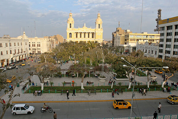
Chiclayo is the principal city of the Lambayeque region in northern Peru. It is located 13 kilometers inland from the Pacific coast and 770 kilometers from the nation's capital, Lima.
Founded by Spanish explorers as "Santa María de los Valles de Chiclayo" in the 16th century, it was declared a city on 15 April 1835 by president Felipe Santiago Salaverry. He named Chiclayo "the Heroic City" to recognize the courage of its citizens in the fight for independence, a title it still holds. Other nicknames for Chiclayo include "The Capital of Friendship" and the "Pearl of the North".
Chiclayo is Peru's fourth-largest city, after Lima, Arequipa, and Trujillo, with a population of 738,000 as of 2011. The Lambayeque region is the fourth most populous metropolitan area of Peru, with a population of 972,713 in 2009.
The city was founded near an important prehistoric archaeological site, the Northern Wari ruins, which constitute the remains of a city from the 7th- to 12th-century Wari Empire.
Chiclayo, because of its location, serves as a point of interconnection for various cities of the Northeast of the country and has various bus companies which service cities such as Lima, Trujillo, Piura, Cajamarca, Chota, Cutervo, Bagua, Jaén, Chachapoyas, and Tumbes.
To adequately accommodate the transportation demand, the city is served by two different land terminals, one located towards the southern end of the city and another at the northern end on the Panamerican Highway. A substantial number of bus companies have their own terminals, many of them located near the downtown of the city and in nearby areas. These interprovincial buses contribute to the congestion experienced in downtown Chiclayo. To try to solve the problem the city government has proposed a plan to build a central station in the city.
Regionally, there are various different public services such as combis, cousters, colectivos, which provide services within the districts and provinces of the department of Lambayeque. There are also an overwhelming number of private taxis which incessantly honk their horns throughout the downtown area of the city, causing a great deal of unwanted noise pollution.
Information about the city Ancash
Ancash is a region of northern Peru. It is bordered by La Libertad Region on the north, Huánuco and Pasco regions on the east, the Lima Region on the south, and the Pacific Ocean on the west. Its capital is the city of Huaraz, and its largest city and port is Chimbote. The name of the region originates from the Quechua word anqash (light, of little weight), from anqas (blue) or from anka (eagle). Ancash is a land of contrasts: it features two great longitudinal valleys, which combine the mountain characteristics of the Callejón de Huaylas (Alley of Huaylas) with the sylvan ones of the Alto Marañón. Miles of sandy beaches and the blue waters of the Pacific. The territory of the coast, high plateaux and Andean punas of the Ancash Region are flat, while the rest of the territory, in the Andes, is very rough. In the west, slopes with strong declivity form narrow canyons with abrupt and deserted sides. The rough territory of the region is crossed by two mountain ranges: on the western side, the Cordillera Negra (Spanish for "black mountain range"), which has peaks without glaciers, and on the eastern side, the Cordillera Blanca ("white mountain range"), which has many peaks covered with snow and ice, such as the Huascarán and the Alpamayo. Between these two mountain ranges, the Santa River flows through the so-called Callejón de Huaylas. This valley narrows to form the Cañón del Pato ("duck canyon"). Also along the Pacific slopes, the Santa River has shaped a wide valley in the punas which narrows into the Cordillera Negra, where the Cañón del Pato canyon was formed. The snow-covered peak of Huascarán, highest peak of Peru and second of the Americas, reaches a height of 6,768 m (22,205 ft, 4.2 miles) and contrasts with the 6,263 m (20,548 ft) deep trough of Chimbote found in the ocean west of Ancash. Remnants of glaciers created many lakes such as Llanganuco Lakes and Lake Parón. Following the Pan-American Highway north from Lima, the territory of the region of Ancash begins just beyond the Fortress of Paramonga, between wide fields of sugarcane, and across the Fortaleza River, 206 kilometres (128 mi) from Lima. Along the coast of Ancash, from the Fortaleza River to the Santa River, the Pacific exerts great influence. The Peruvian current and the El Niño current exert considerable and sometimes tragic effect on local lives and regional economies. Normally, the Peruvian current, also known as the Humboldt Current, brings cold water and large numbers of fish. With the development of the shoals of anchoveta, the Ancash ports and creeks became commercial fishing centers. During the 1950s, the bay of Chimbote was the top fishing port of the world. However, when warmer waters from the north, such as the current of El Niño, bring catastrophic rains to the coast and sea, the shoals of anchoveta disappear, leaving the fishing fleets plants paralyzed, and flooding rivers cause serious damage to the lands and cities. The cycles of these two sea currents that affect Peru are hard to predict. Further north along the Pan-American highway, numerous islands and islets dot the sea near the coast. Most are home only to guano seabirds. From south to north, the most important islands include Tortuga Island (Turtle Island), La Viuda Island (The Widow Island), Isla Blanca (White Island) and Santa Island (Holy Island). The coastal region of Peru includes many peninsulas, creeks, warm bays and sand beaches, full of color. Because of the lack of roads and difficult terrain, many of these are inaccessible by land. The most important beaches include Grande Beach, La Gramita Beach and Las Salinas Beach. Much of this coast is a monotonous stretch of huge sand deserts, a common denominator in all Peruvian coastal regions because of the influence of the Humboldt Current. Along the rivers, there are green valleys, cultivated mainly with sugarcane, rice and cotton. From south to north, the main rivers of the Ancash coast are the following: Huarmey, Culebras, Casma, Sechín, Nepeña, Lacramarca and Santa. Of these rivers, the only one with water year-round is the Santa River. Its sources are the glaciers and lakes of the Cordillera Blanca. The other rivers, as with most rivers of the Peruvian coast, are intermittent, depending on the highland rains or the advance of El Niño.