Information about the city Huancayo
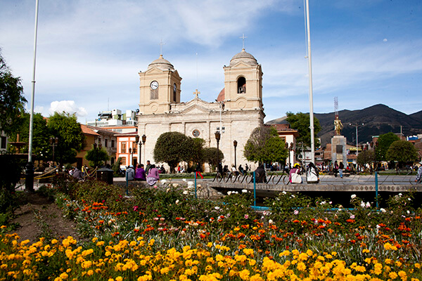
Huancayo is the capital of Junín Region, in the central highlands of Peru. Huancayo is located in Huancayo Province, of which it is also the capital. Situated in the Mantaro Valley at an altitude of 3,271 meters, it belongs to the Quechua region. Depending on delimitation, the agglomeration has a population between 340,000 and 380,000 and is the fifth most populous city of the country. Huancayo is the cultural and commercial center of the whole central Peruvian Andes area.
According to the National Census of 2007 the three main districts of Huancayo have a total population of about 340,000. However, the continuous settlement area have already reached periurban districts, resulting in the agglomeration's population to be at least 380,000 people. Amerindian and Mestizos (Amerindian and Spanish ancestry) are the two largest ethnic groups in the city. Asian (mainly descendants of Japanese and Chinese immigrants) and European descendants are important minority groups.
Huancayo has transportation connections by air, road and rail. The Francisco Carle Airport at Jauja offers daily connections to Lima and is located 45 minutes via car from Huancayo. Current airlines include LATAM Peru, LC Peru, and Peruvian Airlines. To travel by road, the Carretera Central links Huancayo with La Oroya and Lima, which generally takes 7 to 8 hours. Multiple bus carriers operate between Lima and Huancayo daily. The Ferrocarril Central Andino enables transport by rail. Huancayo was a break-of-gauge from 914 mm (3 ft) gauge to 1,435 mm (4 ft 8 1⁄2 in) gauge; for the 147 km extension to Huancavelica. In 2009, this line was being standardized.
Information about the city Cañete (Perú)
San Vicente de Cañete, commonly known simply as Cañete, is a town in Peru, which is the capital of the Cañete Province, in the Lima Region. With a population of 25,829 (1999 estimate), Cañete is the main town of the San Vicente de Cañete District.
The warm and peaceful town of Cañete is located just one and a half hour to the south of Lima (144 km) and serves, for tourists, primarily as a gateway to the Lunahuaná District. The Plaza de Armas lies on 2 de Mayo, a few blocks inland from the spot on the Pan-American Highway, where buses pause for passengers to get on or off. All buses heading south from Lima or north to Lima on the Pan-American Highway pass through Cañete. This is one of the most important homes of the most representative liquor from Peru: the Pisco.
Cerro Azul, Peru is a district north of the city centre San Vicente de Cañete.
The first inhabitants of these lands were the Huarcos. Later, the area was inhabited by descendants of slaves forced to work on the plantations. The slaves and their descendents lived here. The slaves arrived from Guinea, the Congo, and Angola, brought to the Peruvian coast during the seventeenth and eighteenth centuries to work in the cotton and sugar cane fields and in the vineyards.
It also has a district called Asia which has a lot of beaches which people from Lima rent houses and there is also a mall called Sur Plaza Boulevard.